RSM 50 Marine Gyro Stabilizer Excels in SAR Mission Test

-- archive.php --
RSM 50 Marine Gyro Stabilizer

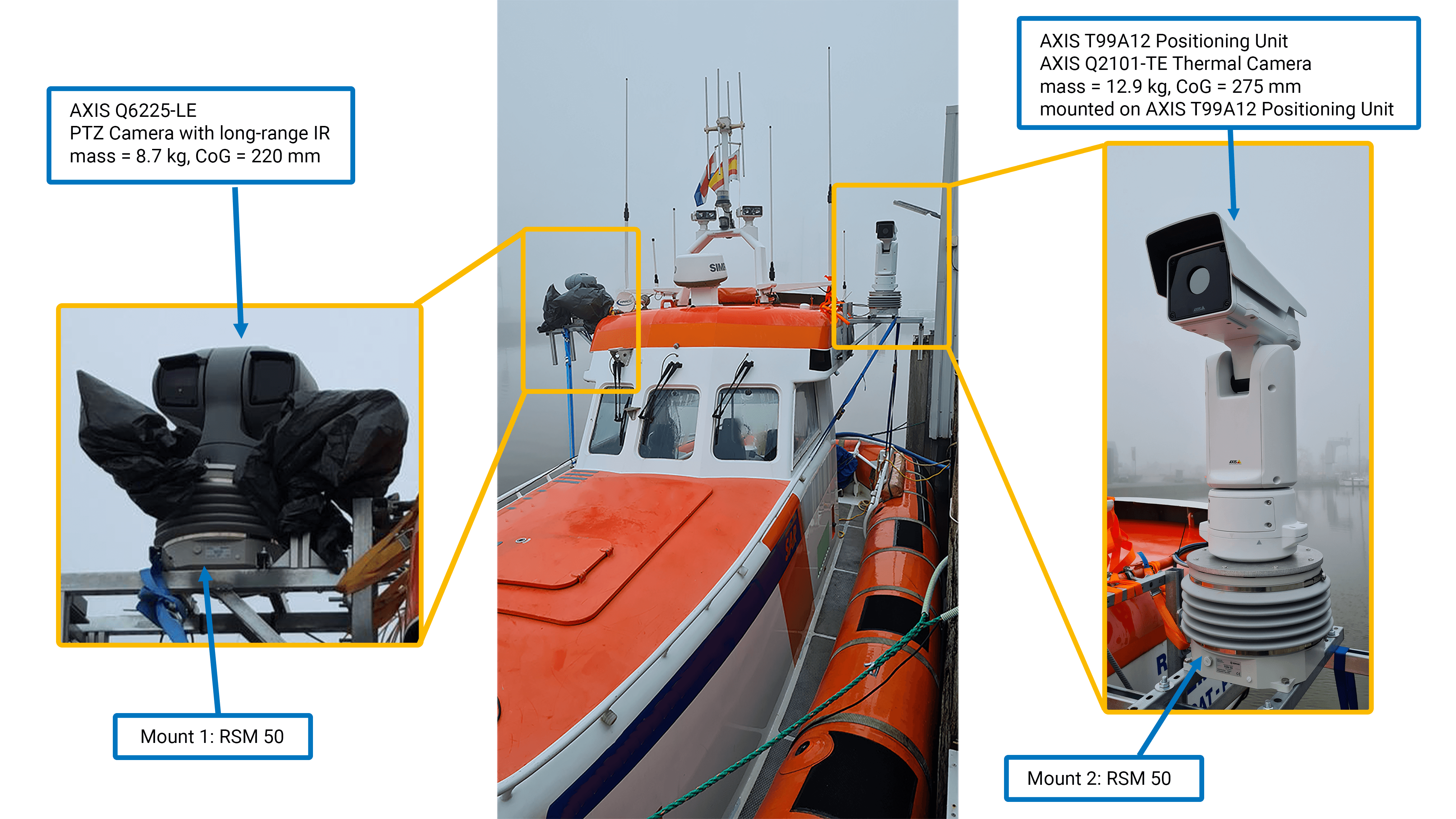
Demonstrated in Successful Maritime Rescue Simulation

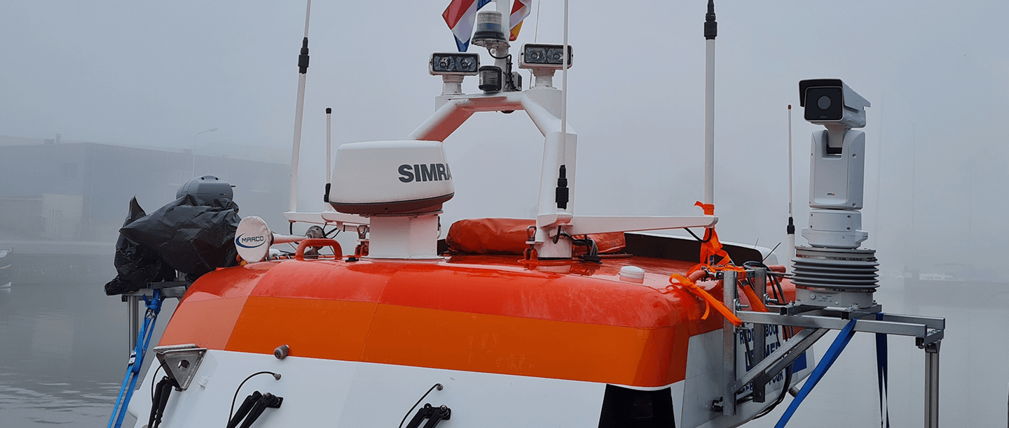
SOMAG AG Jena collaborated with Supervision, a Dutch system integrator specializing in smart camera systems and advanced detection technologies, for a unique maritime rescue simulation on the Ijsselmeer. The goal was to demonstrate the capabilities of our RSM 50 Marine Gyro Stabilizer Mount in a real-world scenario by stabilizing an Axis Q2101-TE positioning camera and a Q6225-LE PTZ camera on a SAR (Search and Rescue) boat used by a Dutch sea rescue organization. This configuration was designed to aid in the detection and identification of individuals in open water, ensuring maximum visibility and stability in critical situations where every second counts.

Advantages RSM 50

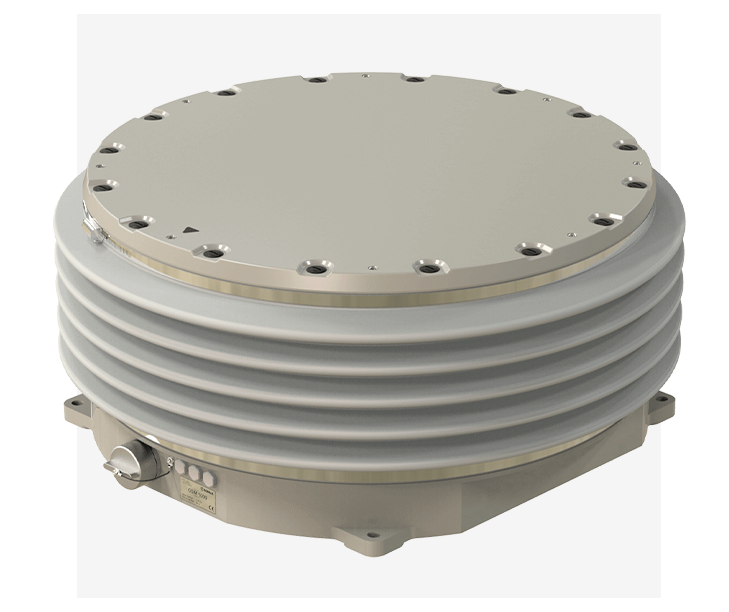
  • Efficient Stabilization

    The RSM 50 stabilizes roll and pitch movements for payloads up to 40 kg with high precision of ≤0.3° rms, making it ideal for optical systems.
  • Compact Design

    Weighing only 11.5 kg and IP67-certified, it is robust, lightweight, and suitable for use in marine environments.
  • Versatile Features

    Energy-saving mode, fail-safe brake system, and flexible mounting options, including inverted installation, ensure adaptability to various applications.

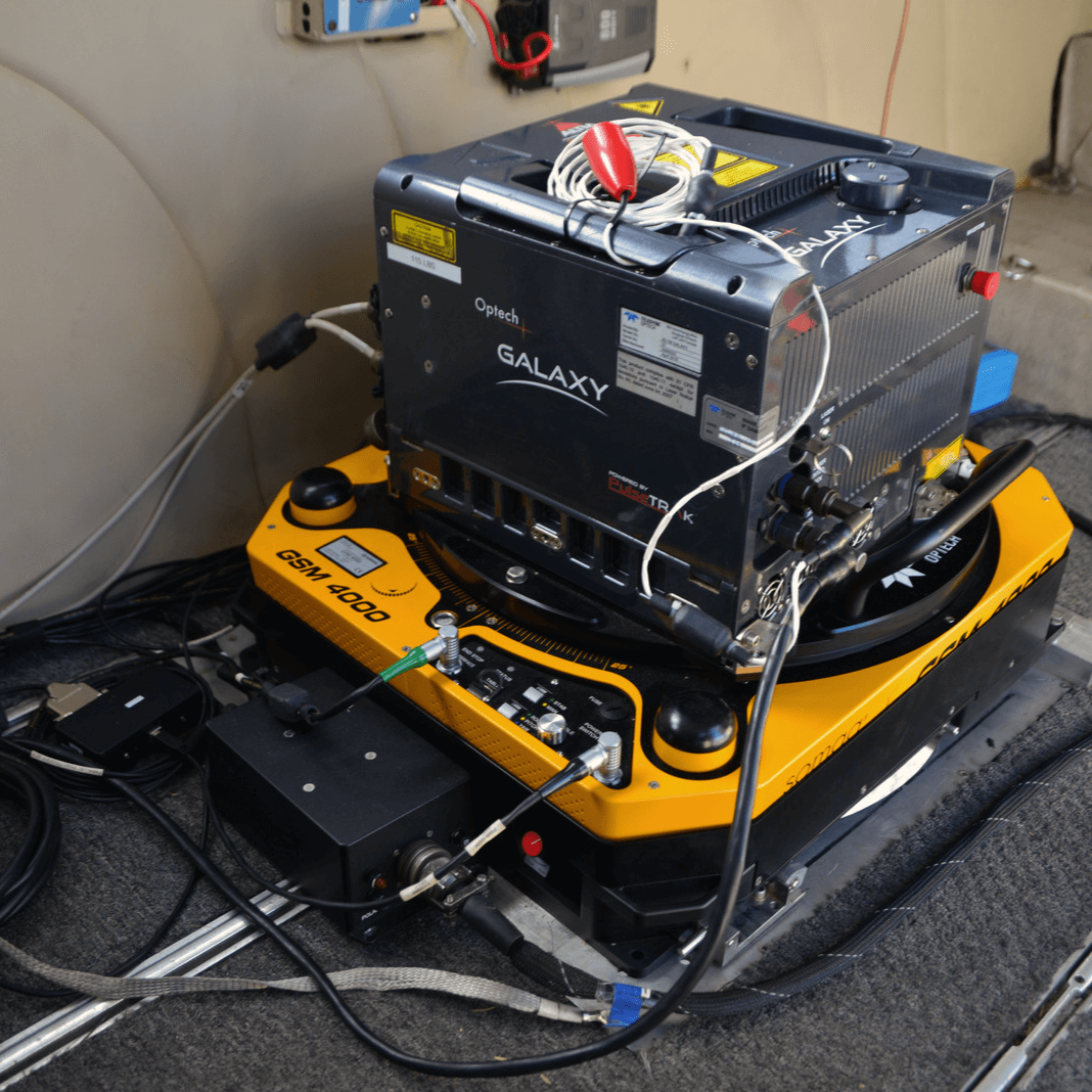
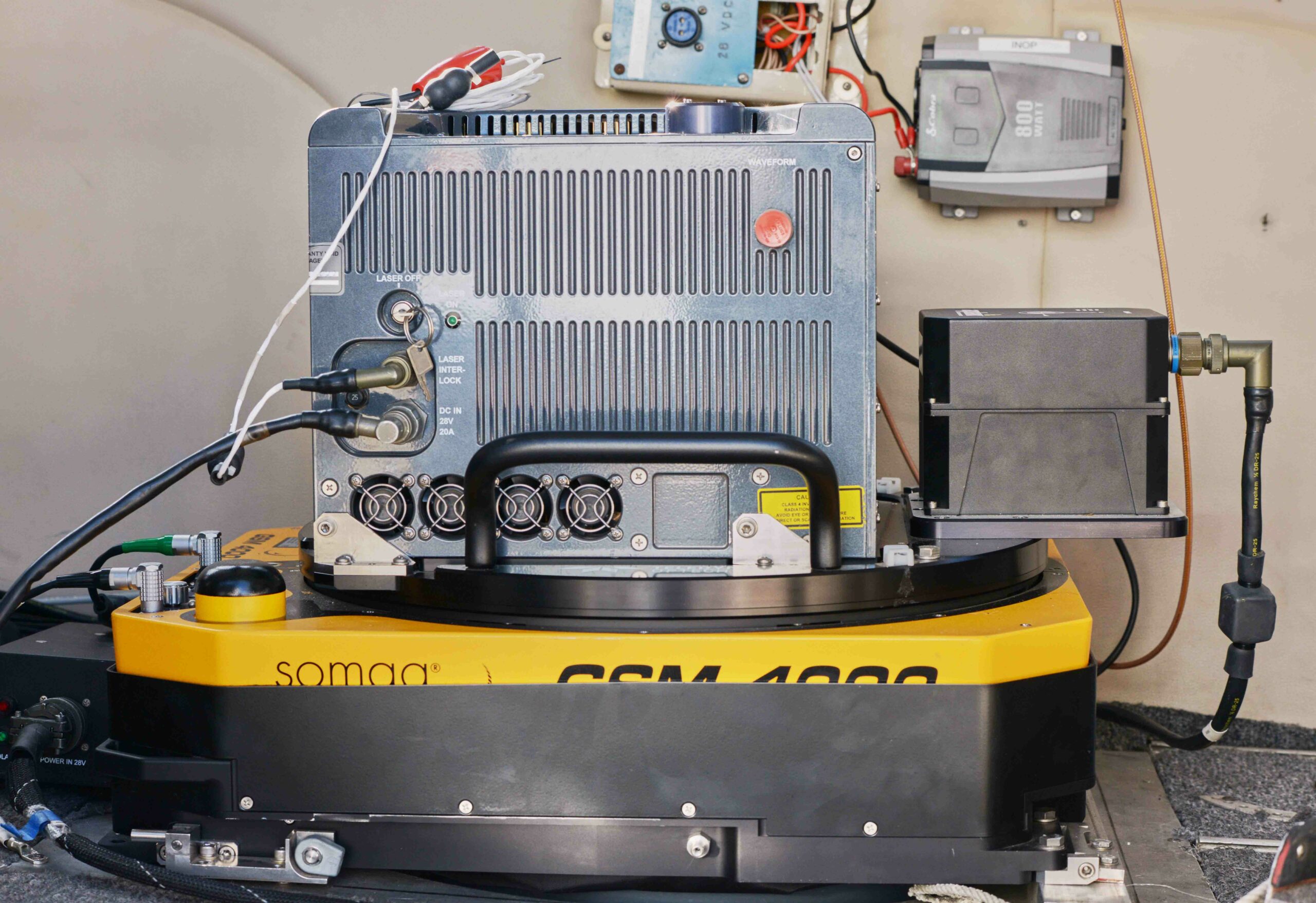
Equipment Setup and Technical Specifications

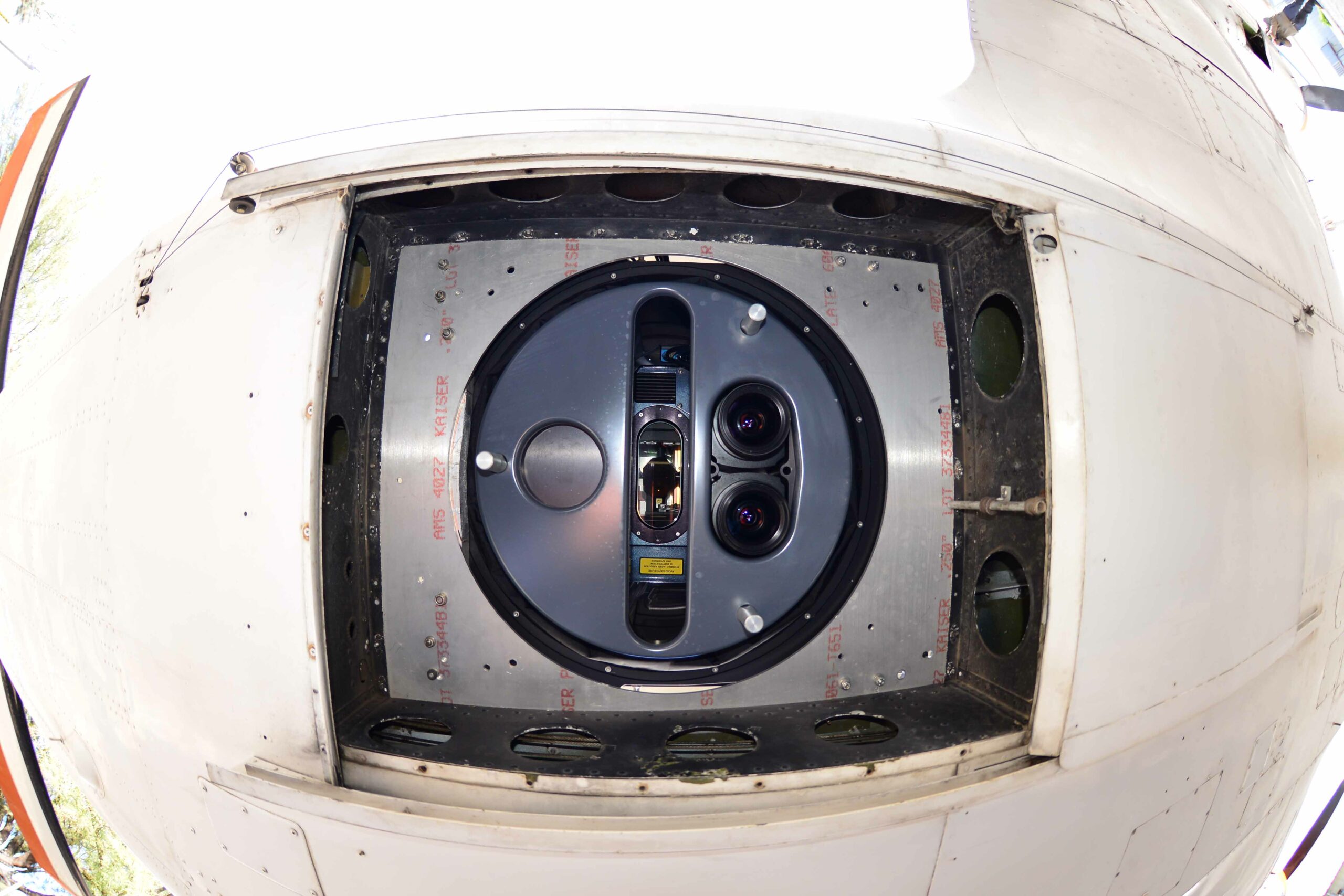
With support from the Dutch sea rescue organization, SOMAG was granted full access to the vessel prior to testing. This allowed the team to meticulously install and configure the RSM 50 Marine Gyro Stabilizer Mount alongside the two cameras, ensuring precise alignment and optimal mounting on either side of the 10.60-meter-long, 4.10-meter-wide SAR boat powered by twin 430 pk Volvo Penta engines. Each camera was carefully positioned using custom mounts, enabling the crew to operate both units effectively under various maritime conditions. The ruggedized stabilization mount proved crucial in maintaining balance and ensuring camera stabilizing performance, even during challenging operations.

The Axis Q2101-TE, mounted on the T99A12 Positioning Unit, was selected for its robust imaging capabilities (12.9 kg weight, center of gravity at 275 mm). The Axis Q6225-LE PTZ Camera (8.7 kg weight, center of gravity at 220 mm) complemented the setup with precise pan, tilt, and zoom functionality. Both cameras were mounted to the RSM 50 Marine Gyro Stabilizer Mount, which excels in gyro-based stabilization, delivering consistent performance across varying speeds and motion intensities. This setup ensured that imaging quality was maintained even in dynamic environments.

Stability and Responsiveness in Action

The trial began with a gradual cruise through the harbor to verify setup integrity and adjust key parameters. As dusk set in, the SAR boat moved into the open waters of the Ijsselmeer, navigating moderate speeds and challenging turning maneuvers. These conditions created wave patterns that required robust stabilization to maintain clear visuals. Despite the shorter wave intervals and the inherent movement of the smaller vessel, the RSM 50 Marine Gyro Stabilizer Mount neutralized environmental impacts effectively, ensuring stable and clear footage.

To showcase the system’s capabilities, a dummy was deployed into the icy water after dark, simulating a real-life search and rescue target at night. Both cameras were actively guided by the gyro stabilization mount, while the positioning unit allowed precise tracking of the dummy across varying distances. This combination provided uninterrupted and stabilized visuals, which the crew monitored in real-time from the cockpit. The seamless integration of camera stabilizing technology proved invaluable in quickly locating the target in challenging conditions.

Results: Enhanced Situational Awareness

Throughout the test, the rescue crew was able to observe the camera feeds directly, experiencing firsthand the difference between the active stabilized setup and a deactivated stabilization mode. The RSM 50 Ruggedized Stabilization Mount demonstrated exceptional performance in managing the ship’s motion, ensuring rapid and accurate visual identification of targets in distress. The use of the RSM 50 reduced the existing movements in this mission data example by ca. 34 times in the roll axis and 24 times in the pitch axis for the sensor system. The crew expressed their appreciation for the added stability, acknowledging the significant impact this technology could have on search and rescue operations.

By the end of the trial, the RSM 50 Marine Gyro Stabilizer Mount impressed the team with its contributions to enhancing situational awareness and operational effectiveness. Stabilized and gyro-based imaging proved to be essential for ensuring clear visuals in time-sensitive scenarios where immediate action can mean the difference between life and death.

Title

RSM 50

STABILIZATION ACCURACY (ROLL AXIS)

RSM 50

STABILIZATION ACCURACY (PITCH AXIS)

Why Customers

Trust Somag

“Stabilizing images with a Somag platform has significantly improved our camera performance. Where onboard detection was previously far from ideal, we are now able to detect objects at 250 meters under night conditions.”

Marc van Niekerk-Thie, CEO Supervision BV

About Supervision BV

Supervision BV, based in Lemmer, Netherlands, specializes in advanced surveillance solutions, including camera surveillance, access control, and smart technologies. Their expertise encompasses AI-driven process optimization, perimeter defense, and the integration of various techniques to prevent unwanted behavior.

About SOMAG AG Jena

SOMAG AG Jena is a global specialist in high-precision gimbal systems. Since 2004, the company has focused on developing and manufacturing Gyro Stabilization Mounts for data acquisition and surveillance applications in the air, on land, and at sea.

The Somag

Product Line-up for Marine Applications

SOMAGs marine product portfolio includes three distinct Gyro Stabilization Mounts. All marine mounts are engineered for operation in harsh weather and water conditions aboard boats, ships, USVs, and buoys. They are compatible with a wide range of sensors, including 360° cameras, thermal imaging systems, video and hyperspectral cameras, laser scanners, and antennas.

  • Offshore Stabilization Mount OSM 5000: Designed for stabilizing heavy single or multi-sensor payloads in marine environments.
  • Nautical Stabilization Mount NSM 500: Tailored for electro-optical reconnaissance and surveillance sensor systems, ensuring situational awareness in maritime settings.
  • Ruggedized Stabilization Mount RSM 50: The smallest and most cost-effective marine gyro stabilizer, suitable for deployment on Unmanned Surface Vehicles (USVs) and small buoys.

OSM 5000

Offshore Stabilization Mount

OSM 5000

NSM 500

Nautical Stabilization Mount

NSM 500

RSM 50

Ruggedized Stabilization Mount

RSM 50

Newsletter

Subsrcibe today!

Keep yourself informed about SOMAG and the latest Gyro Mount technology.
We will send you regular information about:

  • exhibitions and event invitations
  • new products, services and videos
  • latest application examples, projects and partnerships

Subscribe here

Subscribe to the SOMAG newsletter
3D cartography of complete French territory

GSM 4000 contributes to LiDAR HD program

The LiDAR HD program, initiated by IGN, aims to revolutionize national territory mapping through innovative approaches. Tasks encompass acquiring airborne LiDAR data, processing to meet specifications, and automatic classification using a Deep Learning model. These efforts, in conjunction with ground control point measurements, aim to produce comprehensive 3D maps of France by 2025. IGN, a public institution under ecological and forestry ministries, spearheads this project. As part of the France Relance plan, IGN’s LiDAR HD program endeavors to create a comprehensive three-dimensional map of France, excluding French Guiana, by 2025. This « Référentiel à Grande Echelle » (RGE) facilitates data sharing, access, and utilization, addressing various public stakeholders’ needs.

GSM 4000

Advantages for Lidar and Imagery Products

  • Crystal clear aerial imagery

    through precise sensor stabilization during flights
  • Saving of time and money

    time spent on aerial triangulation can be reduced by 20%
  • Flexibility and compatibility

    GSM 4000 is adaptable to any sensor and camera system

Central to IGN’s program is LiDAR technology, which emits high-frequency laser pulses to precisely determine geographical points’ positions. The project is structured into four phases: data acquisition, processing, hosting and distribution, and user support. Ground control points validate aerial data, ensuring mapping accuracy.

Data classification transforms raw point clouds into meaningful information, aiding in disaster prevention, sustainable forest management, energy transition, urban planning, and biodiversity conservation. GEOFIT and SINTEGRA contribute significantly to data collection and processing.

The project’s culmination involves 7,000 planned flight hours over five years, extending beyond conventional 3D cartography. It signifies a future of informed land management, where detailed environmental understanding and access to accurate data play pivotal roles in decision-making.

About IGN

The National Institute of Geographical and Forestry Information (IGN) is a public administrative organisation under the authority of the Ministries of Ecology and Forestry. As a public reference operator, IGN provides geographical and forestry information in France. The mission of the Institute is to produce, visualise, qualify and disseminate the geographic and forestry data that are essential for the implementation of public policies. To this end, IGN develops partnerships in order to focus energies that guarantee rich, comprehensive and up-to-date information.The Institute is a recognised scientific and technical Center thanks to its advanced expertise.

About SOMAG

SOMAG AG Jena is a global specialist for high-precision gimbal systems. The company focuses since 2004 on the development and manufacture of Gyro Stabilization Mounts for data acquisition and surveillance applications in the air, on land and at sea. The airborne product portfolio comprises three different Gyro Stabilization Mounts for large format, multiple medium format and single medium format sensors. All aerial camera stabilizers are designed for operation inside airplanes, helicopters or UAVs.

Newsletter

Subscribe today!

Keep yourself informed about SOMAG and the latest Gyro Mount technology.
We will send you regular information about:

  • exhibitions and event invitations
  • new products, services and videos
  • latest application examples, projects and partnerships

Subscribe here

Subscribe to the SOMAG newsletter
Special Trade-In Offer

Save Up to 15,000 Euros!

As previously announced, our support for the GSM 3000 series is ending. Effective January 1, 2025, we will no longer offer maintenance and repair services for the GSM 3000. If you still own a GSM 3000 device, we have an exciting offer for you.

To make this transition easier, we have prepared an unbeatable offer for our customers: trade in your current GSM 3000 for its successor, the GSM 4000, and and save up to 15,000 euros! This limited-time offer is available to our valued customers who want to stay ahead with the latest technology.

Why upgrade to the GSM 4000?
The GSM 4000 sets the benchmark for large format cameras and scanners, offering unparalleled stability and performance for airborne surveying. The Gyro Mount adapts to any sensor and camera on the market, providing maximum flexibility in equipping your aircraft. Its high level of stabilization is critical for achieving the best results in mapping, surveying, and remote sensing projects. By significantly enhancing the efficiency and precision of both airborne imagery and LiDAR data collection, the GSM 4000 ensures that your projects meet the highest quality standards.

How to take advantage
Ready to elevate your surveying technology? Contact our sales or support team directly to learn more about this offer and begin your trade-in process. Our experts are here to answer your questions and assist you every step of the way.

Don’t miss out on this unique opportunity to be at the forefront of surveying technology. The GSM 4000 is waiting for you!

We are here to help

Sales and Support

Sören Lieske
Sales Manager
Phone: +49 3641 633 68 18
E-Mail: s.lieske@somag-ag.de
Let’s connect on LinkedIn

Johannes Dreyer
Support Manager
Phone: +49 3641 633 68 17
E-Mail: j.dreyer@somag-ag.de
Let’s connect on LinkedIn

Newsletter

Subsrcibe today!

Keep yourself informed about SOMAG and the latest Gyro Mount technology.
We will send you regular information about:

  • exhibitions and event invitations
  • new products, services and videos
  • latest application examples, projects and partnerships

Subscribe here

Subscribe to the SOMAG newsletter

High-density LiDAR and high-resolution imagery collection with Gyro Stabilization Mount GSM 4000 for flood study

Cooper Aerial Surveys was contracted by Helm Engineering to provide aerial lidar mapping of the Pahrump site for a flood study over the entire Nye County. Pahrump is a town located at the southernmost tip of Nye County, Nevada, about 62 miles (100 km) west of Las Vegas, adjacent to the Nevada–California border. The results of this survey help mitigate flood damage for existing and future projects.

Cooper Aerial Surveys uses a multi-sensor aerial system stabilized by a single SOMAG Gyro Stabilization Mount GSM 4000 to obtain the highly accurate lidar and aerial imagery data. The Mount helps to hold the sensors in place and compensates for movement as the aircraft moves down the flight line or crabs, ultimately resulting in crystal clear aerial imagery and even better quality data being captured for the entire mapping project.

GSM 4000

Advantages for Lidar and Imagery Products

  • Crystal clear aerial imagery

    through precise sensor stabilization during flights
  • Saving of time and money

    time spent on aerial triangulation can be reduced by 20%
  • Flexibility and compatibility

    GSM 4000 is adaptable to any sensor and camera system

To complete the project, Cooper Aerial collected 10cm GSD color imagery and 20 points per square meter LiDAR over the client-defined mapping limits. The project area covered roughly 171,000 acres (268 Sq Miles) of land. Aerial photography consisted of 31 flight lines with 2304 exposures, with a total of 523 mapping models.

The mapping data was used to compile a 1″ = 40″ stereo map to create all planimetric features and 3D Digital Terrain Model (DTM) for 1′ contour generation. Contour data was derived from LiDAR data and included major breaklines and hydro flattening.

By using the data collected by Cooper Aerial, Helm Engineering was able to create models to identify potential areas that were highly exposed to risks of flooding. Some of these hazardous areas contain high-end real estate communities worth several millions of dollars that need to be protected against these risks. Furthermore, this flood study allows the county to learn more about the impacts of a major flood event if preventative measures are not taken. Planimetric features included impervious surfaces (paved lots, roads, concrete), buildings, dirt roads, and drainage features. Cooper Aerial used the surface that was derived from the lidar data to create orthorectified photos, which were useful in the collection of planimetric features as well as quality control purposes.

Improved efficiency

Maximum quality at minimum cost and time

Cooper Aerial is the largest firm in the Southwest, dedicated to providing leading edge aerial mapping solutions throughout the United States, Mexico, and Canada. To maximize time and cost efficiency without sacrificing the quality the customer expects, they use an integrated hybrid dual collection system consisting of a Teledyne Galaxy Prime Lidar and a Phase One 280 MP camera installed in a SOMAG Gyro Stabilizer GSM 4000 Mount.

This system enables a single mobilization of the lidar and camera in a seamless mission with only one aircraft, making the most of weather windows and generating matching data sets. This approach significantly minimized the project cost by about half of the flight cost, roughly $76,000. Without such a system, meeting the project deadline would have required mobilizing more aircraft or extending turnaround time.

Moreover, Cooper’s installation of the GSM 4000 provides it with clean data that is easier to process. This allowed the company to reduce the time required for aerial triangulation by 20%, which lowered the overall cost of the project for the customer.


Why Customers

Trust Somag

“SOMAG is the leading provider of gyro stabilized mounting systems and provides high accuracy for large-format, LiDAR, and photogrammetry. As the market leader, SOMAG has the biggest market share in its industry and this is not random. SOMAG has a great pricing point and good customer service and therefore it was an easy choice for us to go with them. In addition to SOMAG’s quality product, we appreciate the fact that the GSM 4000 is adaptable to any sensor and camera in the marketplace which gives us more flexibility on how we can equip our aircrafts.”

Zachary Radel, Sr. Project Manager at Cooper Aerial Surveys Co.
Video

Watch the GSM 4000 in field

About Cooper Aerial

Cooper Aerial boasts a well-connected staff of photogrammetrists, imagery specialists, project managers, marketing, traditional survey experts, aerial imagery collection experts, and GIS specialists. The company provides professional photogrammetric mapping and imagery services for a variety of industries to governmental, engineering, and developmental organizations. Simultaneous data acquisition is used on customer projects in civil engineering, hydrology, energy, forestry and military sectors.

About SOMAG

SOMAG AG Jena is a global specialist for high-precision gimbal systems. The company focuses since 2004 on the development and manufacture of Gyro Stabilization Mounts for data acquisition and surveillance applications in the air, on land and at sea. The airborne product portfolio comprises three different Gyro Stabilization Mounts for large format, multiple medium format and single medium format sensors. All aerial camera stabilizers are designed for operation inside airplanes, helicopters or UAVs.

Newsletter

Subscribe today!

Keep yourself informed about SOMAG and the latest Gyro Mount technology.
We will send you regular information about:

  • exhibitions and event invitations
  • new products, services and videos
  • latest application examples, projects and partnerships

Subscribe here

Subscribe to the SOMAG newsletter
Customer Success Story

Simultaneous Lidar Data and Aerial Imagery Collection with GSM 4000

95West Aerial Mapping revolutionizes simultaneous large-format imagery and high-density lidar collection with a dual GSM 4000 gimbal setup. The US-based company has been performing simultaneous collections for many years. When they decided to upgrade their current equipment, they opted for two SOMAG GSM 4000s as their preferred Gyro Stabilization Mounts for their state-of-the-art sensors. Simultaneous data collection allows the company to serve customers with maximum quality and efficiency.

The Gyro Stabilization Mount 4000 provides industry leading pitch, roll, and yaw stabilization for airborne cameras, scanners, LiDARs and other imaging sensors up to 120 kg during flight missions. Since September 2021, 95West has been operating the dual GSM 4000 Mounts in a Cessna Caravan to stabilize a Vexcel UltraCam Eagle M3 and a Riegl VQ-1560 II-S scanner. The Gyro Mount ensures high quality aerial images taken with the large format camera and a regular distribution of measurement points on the ground for the Lidar scanner, as well as a significant increase in efficiency when flying over large areas by reducing the required overlap of neighboring scan strips.

Two SOMAG GSM 400 Gyro Mounts - left in SOMAG signature yellow, right in UltraMount design stabilizing a Riegl lidar scanner and an UltraCam aerial camera
Two GSM 400 Gyro Mounts – left in SOMAG signature yellow, right in UltraMount design
GSM 4000

Advantages for Lidar and Imagery Products

  • Crystal clear aerial imagery

    through precise sensor stabilization during flights
  • Saving of time and money

    time spent on aerial triangulation can be reduced by 20%
  • Flexibility and compatibility

    GSM 4000 is adaptable to any sensor and camera system
Why Customers

Trust Somag

“SOMAG is the leading provider of gyro stabilized mounting systems and provides high accuracy for large-format, LiDAR, and photogrammetry. As the market leader, SOMAG has the biggest market share in its industry and this is not random. SOMAG has a great pricing point and good customer service and therefore it was an easy choice for us to go with them. In addition to SOMAG’s quality product, we appreciate the fact that the GSM 4000 is adaptable to any sensor and camera in the marketplace which gives us more flexibility on how we can equip our aircrafts.”

Zachary Radel, Sr. Project Manager at Cooper Aerial Surveys Co.
Improved efficiency

Maximum quality at minimum cost and time

Top view on two SOMAG gimbals with a Riegl lidar scanner and a Vexcel Imaging aerial camera system

With small time windows for data acquisition due to weather, sun angle limitations, and seasonal changes, the number of flight hours per season is limited. By acquiring lidar and imagery data in the same flight, weather windows are maximized and mobilization and acquisition costs are halved.

All advantages at a glance:

  • Coincident datasets reflect same features and water levels eliminating discrepancies
  • Single mobilization expense
  • More efficient acquisition 
  • Maximum utilization of weather windows
  • Larger image footprints and swath widths 
  • Increased detail and precision 
  • Data versatility 
  • Current terrain data for orthorectification 

“We find that many of our clients prefer simultaneous collection. Even customers who would not normally use both lidar and imagery have chosen to acquire both systems because of the greater versatility and benefits.”
– Andrew Werle, 95West Aerial Mapping

Customers from diverse sectors benefit from the dual solution. Engineering and utility customers use the highly accurate terrain models for design while using the high-resolution imagery as a background raster for their drawings. Customers in the mining and commodities industries are able to monitor properties and calculate volumes in a single flight. For orthophotography customers, a much better product can be delivered because the most current surface data can be used for rectification.


95West operating the dual GSM 4000 Gyro gimbals in a Cessna Caravan
Video

Watch the GSM 4000 in field

The video shows the self test of the GSM 4000. It consists of a mechanical and an electronic test phase. The self test executes a routine, which checks all sensors, mechanics and electronics and saves the results in a text file. SOMAG can decrypt this text file and utilize it for trouble-shooting purposes. The test can be performed in the SOMAG Mount Control App. which is delivered together with each Gyro Mount on a USB stick.

About SOMAG AG Jena:

SOMAG AG Jena is a global specialist for high-precision gimbal systems. The company, consisting of hand-picked experts in the fields of electronics, mechanics and software, focuses since 2004 on the development and manufacture of Gyro Stabilization Mounts for data acquisition and surveillance applications in the air, on land and at sea.

About 95West Aerial Mapping:

95West Aerial Mapping is a wholly owned subsidiary of Widseth that provides aerial acquisition and geospatial services throughout the United States and Canada. 95West specializes in unique solutions utilizing cutting edge equipment to deliver services that are tailored to their clients’ needs with the latest technology in the aerial industry.

Newsletter

Subscribe today!

Keep yourself informed about SOMAG and the latest Gyro Mount technology.
We will send you regular information about:

  • exhibitions and event invitations
  • new products, services and videos
  • latest application examples, projects and partnerships

Subscribe here

Subscribe to the SOMAG newsletter
Nato Exercise

NSM 400 as part of counter-drone system

SOMAG’s NSM 400, a Gyro Stabilization Mount designed to enhance the performance of sensors systems in mobile applications, is part of the counter-drone system Snow Leopard. The system is an evolution of Elettronica’s ADRIAN anti-drone system and was presented in early March on the occasion of NATO’s innovative White Fox exercise and conference held in Sestriere, Italy.

The system is characterized by its capabilities to operate in motion and under extreme operating conditions by using artificial intelligence techniques combined with signal analysis and image processing. Based on the operational requirements and concept of operations, the anti-drone system uses electro-optical devices and RS Scanner/DF as the only detection sensors. The stabilization platform compensates for vehicle movements in the roll and pitch axes in real time and precisely levels the sensor system to enable the identification and classification of drones at a distance. This guarantees an adequate response time.

The NSM 400 can be deployed on any kind of mobile vehicle. For this particular demonstration, the whole system was installed on a BV S7 vehicle of the Italian Army, but can also be installed on any other vehicle to provide protection for dismounted convoys and fixed targets.

Newsletter

Subscribe today!

Keep yourself informed about SOMAG and the latest Gyro Mount technology.
We will send you regular information about:

  • exhibitions and event invitations
  • new products, services and videos
  • latest application examples, projects and partnerships

Subscribe here

Subscribe to the SOMAG newsletter